


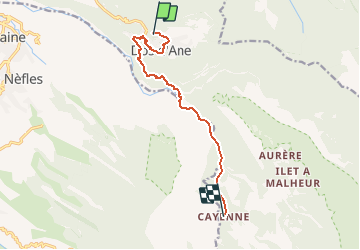
Dos d'Âne - Cayenne

ARVIEU
User

Length
12.1 km

Max alt
1052 m

Uphill gradient
668 m
Km-Effort
23 km

Min alt
248 m

Downhill gradient
1146 m
Boucle
No
Creation date :
2019-01-15 18:27:50.326
Updated on :
2019-01-15 18:27:50.326
6h00
Difficulty : Difficult

FREE GPS app for hiking
 SityTrail
IGN / Geographical institutes
SityTrail Plus
The world is yours!
About
Trail Walking of 12.1 km to be discovered at Réunion, Unknown, La Possession. This trail is proposed by ARVIEU.
Description
Descente technique sur la rivière des galets que l'on doit traverser à quatre reprises. Montée sans difficulté sur Cayenne
Positioning
Country:
France
Region :
Réunion
Department/Province :
Unknown
Municipality :
La Possession
Location:
Unknown
Start:(Dec)
Start:(UTM)
331641 ; 7679155 (40K) S.
Comments